Decoding a METAR: How Pilots Read the Weather
A METAR (Meteorological Aerodrome Report) is a standardized format for reporting weather observations, crucial for aviation operations. These reports provide a snapshot of weather conditions at an airport or aerodrome, typically updated every hour.
Decoding a METAR might seem daunting due to its concise and coded format, but with practice, it becomes an invaluable skill for pilots, meteorologists, and aviation enthusiasts.
Structure of a METAR
A METAR report consists of several components, each conveying specific weather information. Here's a typical structure:
- Type of Report (METAR or SPECI)
- Station Identifier
- Date and Time
- Modifier (if any)
- Wind Information
- Visibility
- Weather Phenomena
- Sky Condition
- Temperature and Dew Point
- Altimeter Setting
- Remarks (if any)
Let's Break it Down
1. Type of Report
- METAR: A routine weather observation.
- SPECI: A special weather observation issued when significant changes occur outside the normal reporting time of a METAR.
In our example, it's a METAR.
2. Station Identifier
The station identifier is a four-letter ICAO code representing the reporting airport.
- KCHA: Lovell Field Airport (Chattanooga, Tennessee, USA)
3. Date and Time
The date and time are in UTC (Coordinated Universal Time) format, indicating when the observation was made.
- 282011Z: 28th day of the month at 20:11 UTC (also referred to as Zulu Time).
28: Day of the month2011: Time (20:11 UTC)Z: Zulu time (UTC)
4. Modifier (if any)
Modifiers like AUTO indicate an automated report. If missing, it’s a manual observation completed by a certified weather observer.
In our example, there is no modifier, implying a manual report.
5. Wind Information
Wind information includes direction and speed.
- 27004KT:
270: Wind direction (270 degrees, from the west)04: Steady state wind speed (04 knots)
KT: Knots (wind speed unit)
They may also indicate the gusts by adding a G to the end of the steady state wind speed. For example: 27004G15KT would indicate a 15 knot gust.
6. Visibility
Visibility is reported in statute miles (SM).
- 04SM: Visibility of 04 statute miles.
In the United States 10SM is the limit for reporting good visibility, other parts of the world may report up to 30SM for good visibility.
7. Weather Phenomena
Weather phenomena use specific codes to describe conditions.
- -TSRA: Light rain (
-for light,RAfor rain) and Thunderstorms (TSfor thunder).
Before the weather phenomena you can have a + or - which indicates either Heavy or Light precipitation, if nothing it's considered Moderate. And it only modifies the precipitation in the weather, so in this example it's not Heavy Thunderstorms. It's Thunderstorms and Light Rain.
8. Sky Condition
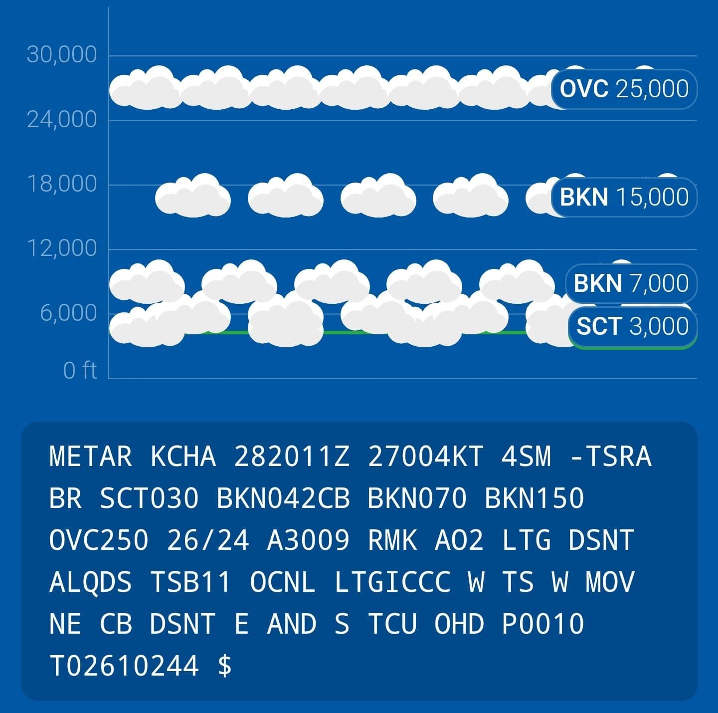
Sky condition reports cloud coverage and heights in feet above ground level (AGL).
- SCT030: Scattered clouds at 3,000 feet.
- BKN042CB: Broken clouds at 4,200 feet (Cumulonimbus type clouds)
- BKN070: Broken clouds at 7,000 ft.
- BKN150: Broken clouds at 15,000 feet.
- OVC250: Overcast clouds at 25,000 feet.
We consider the first BKN or OVC layer as the 'ceiling' of weather. Which is how most pilots calculate if the weather is high enough to fly or make landings at airports.
9. Temperature and Dew Point
Temperature and dew point are reported in degrees Celsius.
- 26/24:
26: Temperature (26°C)24: Dew point (24°C)
It's a general rule that if the temperature and dew point are within 3 degrees of each other, you have a significant risk of fog to develop. The dew point will never be more than the temperature, and will only equal, meaning the air is completely saturated with moisture.
10. Altimeter Setting
The altimeter setting is given in inches of mercury (inHg).
- A3009: Altimeter setting of 30.09 inches of mercury.
We consider 29.92 inches of mercury standard and anything below is considered low pressure and anything higher is high pressure.
11. Remarks (if any)
Remarks provide additional information, often using specific codes. Most people will skip over this jumble of words but they can have some key indicators to them.
- RMK A02 LTG DSNT ALQDS TSB11 OCNL LTGICCC W TS W MOV NE CB DSNT E AND S TCU OHD P0010 T02610244 $:
RMK: RemarkAO2: Automated station with a precipitation sensorLTG DSNT ALQDS: Lightning distant all quadrantsTSB11: Thunderstorms began at11minutes past the hourOCNL LTGICCC W: Occasional lightning in clouds and cloud to cloud westTS W MOV NE: Thunderstorms west moving in a northeast directionCB DSNT E and S: Cumulonimbus type clouds distant in the east and southTCU OHD: Towering Cumulus overheadP0010: Precipitation amount of 0.1 inches since last METART02610244: Hourly temp and dew point to the 0.1 of a degree. Temperature 26.1°C and Dew point 24.4°C$: Maintenance is needed on the system.
Additional METAR Codes
CAVOK: Ceiling and visibility OK (no significant weather below 5,000 feet).NSC: No significant cloud (no cloud below 5,000 feet and no significant weather).VV*: Vertical visibility (used when sky is obscured, followed by height in hundreds of feet).
The FAA has an entire METAR ABBREVIATIONS key to decode METARs. This is just a small sampling, what can be in a METAR and even the professionals, like myself, need to look up what something means.
Final Thoughts
Decoding a METAR is a skill that enhances situational awareness for aviation professionals. By breaking down each component, you can quickly interpret the weather conditions at an aerodrome, ensuring safer and more informed decision-making. It takes awhile to really master the skill of reading a METAR fast and accurately, but if you can master the skill, you'll be significantly on your way to master the rest of the aviation jargon.


